
The Earth’s surface, dynamic and ever-changing, is shaped by powerful forces operating beneath the crust. Among the key theories explaining these processes are Alfred Wegener’s Continental Drift Theory and the modern understanding of Plate Tectonics. These concepts are fundamental to understanding earthquakes and volcanoes, two of the most dramatic natural phenomena.
Wegener’s Continental Drift Theory
In 1912, Alfred Wegener proposed the Continental Drift Theory, suggesting that the continents were once joined together in a single supercontinent called “Pangaea.” Over millions of years, Pangaea fragmented, and the continents drifted to their current positions.
Wegener supported his hypothesis with several lines of evidence:
- Fossil Correlation: Identical fossils of plants and animals, such as Mesosaurus and Glossopteris, were found on continents now separated by oceans.
- Geological Similarities: Mountain ranges and rock formations on different continents matched perfectly, such as the Appalachian Mountains in North America aligning with mountain ranges in Scotland.
- Climate Evidence: Glacial deposits in regions now tropical and coal deposits in cold areas suggested significant shifts in continental positioning.
Despite its compelling evidence, Wegener’s theory was not widely accepted during his lifetime due to the lack of a mechanism explaining how continents moved.
Plate Tectonics: The Modern Perspective
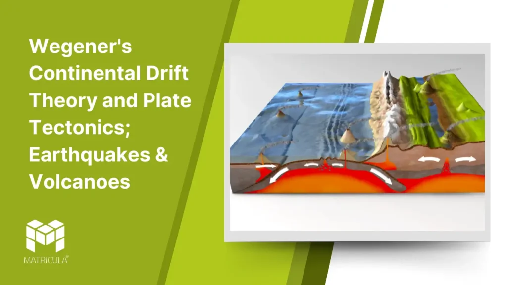
The theory of Plate Tectonics, developed in the mid-20th century, provided the mechanism that Wegener’s theory lacked. The Earth’s lithosphere is divided into large, rigid plates that float on the semi-fluid asthenosphere beneath. These plates move due to convection currents in the mantle, caused by heat from the Earth’s core.
Plate Boundaries
Divergent Boundaries: Plates move apart, forming new crust as magma rises to the surface. Example: The Mid-Atlantic Ridge.
Convergent Boundaries: Plates collide, leading to subduction (one plate sinking beneath another) or the formation of mountain ranges. Example: The Himalayas.
Transform Boundaries: Plates slide past each other horizontally, causing earthquakes. Example: The San Andreas Fault.
Earthquakes
Earthquakes occur when stress builds up along plate boundaries and is suddenly released, causing the ground to shake. They are measured using the Richter scale or the moment magnitude scale, and their epicenters and depths are crucial to understanding their impacts.
Types of Earthquakes
Tectonic Earthquakes: Caused by plate movements at boundaries.
Volcanic Earthquakes: Triggered by volcanic activity.
Human-Induced Earthquakes: Resulting from mining, reservoir-induced seismicity, or other human activities.
Volcanoes
Volcanoes are formed when magma from the Earth’s mantle reaches the surface. Their occurrence is closely linked to plate boundaries:
Subduction Zones: As one plate subducts, it melts and forms magma, leading to volcanic eruptions. Example: The Pacific Ring of Fire.
Divergent Boundaries: Magma emerges where plates pull apart, as seen in Iceland.
Hotspots: Volcanoes form over mantle plumes, independent of plate boundaries. Example: Hawaii.
Types of Volcanoes
Shield Volcanoes: Broad and gently sloping, with non-explosive eruptions.
Composite Volcanoes: Steep-sided and explosive, formed by alternating layers of lava and ash.
Cinder Cone Volcanoes: Small, steep, and composed of volcanic debris.